Near Tulum the longest underwater cave system has been mapped. And work is still ongoing. For decades, specialized cave divers have measured inch by inch miles of caves connected by passageways where a human or a mammoth can traverse, or thinner than hair.
Diving in such unique settings require detailed training, specialized technical gear and it is mandatory to hold an international certification for cave diving; for which you can train and test. Speleo diving routes must be clearly marked with a lifeline and arrows pointing the exit. If there is no line, only recognized local based explorers can venture inside and start one. However, this treasure is available not only for specialized cave divers, but also for us simple beings that can enjoy the caverns and entrances, as amazing as the rest of the cave. In the Yucatan we call these entrances cenotes.

Figure 1 Río Secreto, Playa del Carmen, Quintana Roo. © Río Secreto.
The legendary speleo divers that have ventured inside the caves have made unbelievable discoveries inside these breathtaking underground systems; one being the oldest and most complete human skeleton found in America, dating 13,000 years of age. Several others have been located, dating from different times, and signing for the continual dwelling of the caves since then. Besides the human bones, specimens of paleolithic fauna have been preserved; inviting us to go further, at least on paper, on the topic of caves as windows to prehistory.
Caves and its speleothems form drop by drop, particle to particle, in an ongoing process of tens to hundred thousand years; If a stalactite is dripping, it is still active; if we touch it with the tip of our fingers, we will disrupt this process and it will instantly stop growing. It is fundamental that on our visits to caves, grottos, or sinkholes we avoid touching any formation, and follow the indications of the personnel in charge of the location. Since 2017 there is a municipal rulebook in Quintana Roo that aims to regulate the tourist and human interaction with these fragile places. Bringing awareness to tour providers and cenote owners on the importance of adhering to the rulebook is still a challenge, for the entrances to the caves are private property if the land where they are is owned by someone, but once inside they are all interconnected. It is the obligation of everyone to protect the hydrogeological system that underlies the Yucatan peninsula; and not only it is the only source of fresh water in the whole area, but it also offers exceptional natural attractions that can be visited orderly, minimizing the impact; and it preserves in its interior vestiges from the past that we are just beginning to discover.
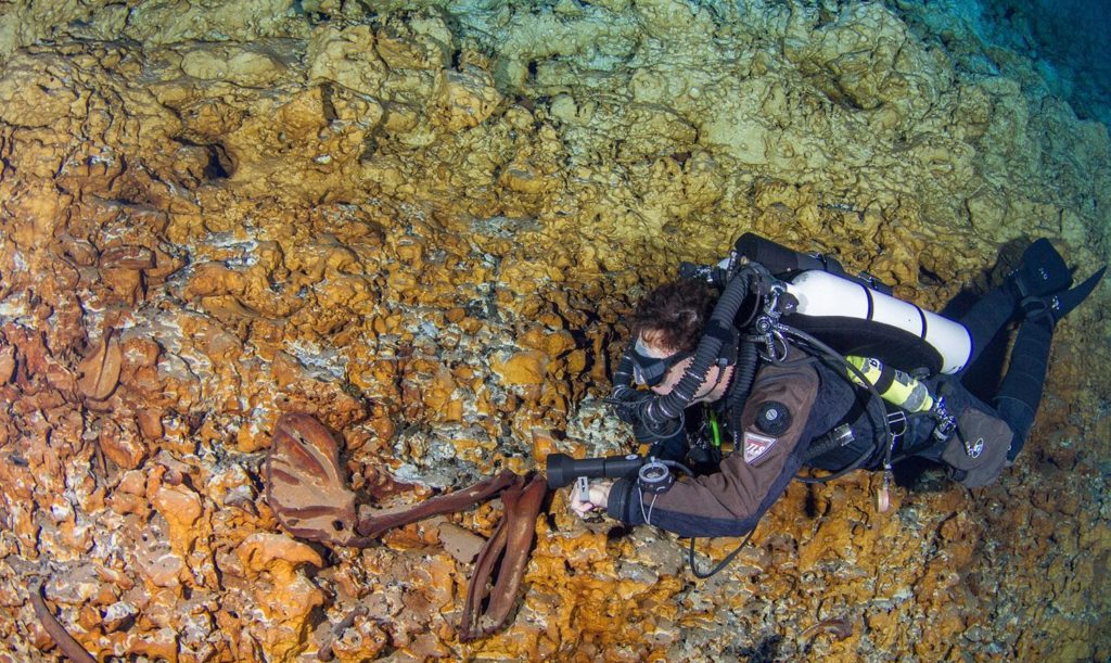
Figure 2 Espeleobuzos realizando exploraciones. © Archivo INAH.
Sac Actun is an underground cave system South of the Riviera Maya; it has been named the longest underwater cave system in the inundated world; surpassing Puerto Princesa River in the Philippines and Mammoth Cave System in the U.S. once its connection with the Dos Ojos system was finally mapped. A few miles down the road, near the entrance to Sian K’aan biosphere reserve, the impressive Ox Bel Ha system is located. The massive cave network under Quintana Roo is barely being unveiled; mostly by the evolution of technology and the perseverance of local explorers that for almost half a century have logged each inch, using any method available and even developing the gadgets needed; and many hours of exploration.
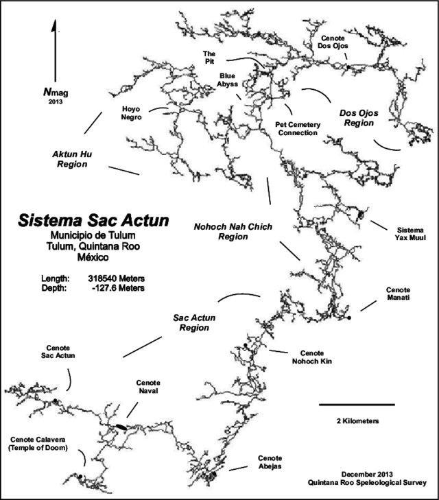

Figure 3 Sac Actún system. Tulum, Quintana Roo. © Quintana Roo Speleological Survey 2013.
In one of the farthest areas of the Sac Actun system, the Hoyo Negro cave is located. In it, the paleontological findings overturned the amazement of it being the longest underground river.
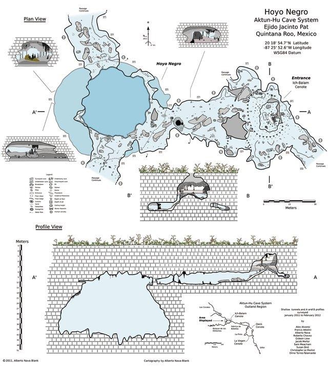
Figure 4 Map of Hoyo Negro cave, Sac Actún system, Tulum, Quintana Roo. © Alberto Nava.
In the geological epochs, the Pliocene brought us the collision of North and South America, creating both the Rocky Mountains and the Panama Isthmus. Also, the Himalayas were formed. This caused a change in atmospheric and oceanic circulation that had diverse effects on climate and global temperature, thus shifting into the Pleistocene, the ice age.
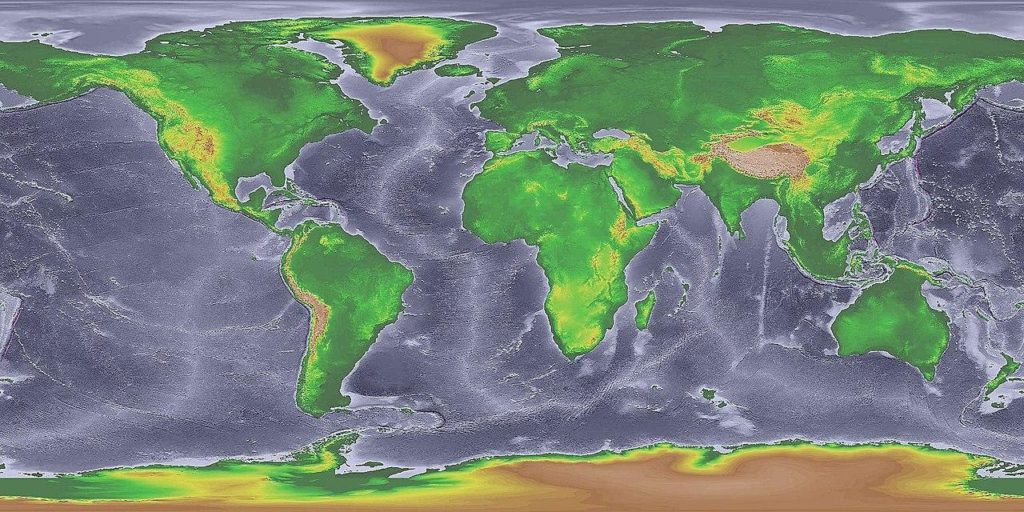
Figure 5 Oceanic level in the Pleistocene Epoch. © National Oceanic and Atmosferic Administration.
During the Pleistocene, that goes from 2.4 million years to around 11,000 years ago, the caves located in the Yucatan were not submerged, as today. Glaciations and the collision of the North and South American halves caused that fauna from either side traversed in the opposite direction, including humans, and some migrants ventured inside the caves seeking refuge or fresh water, but in the pitch-dark caves the fell into holes or found galleries with no exit. Their remains integrated into the sediment of the caves. Speleological explorations, spanning decades and now blessed with 3D digital technology, have boosted the knowledge, the understanding of the vast hydrogeological system that we have beneath; one that most of us ignore, and we all surely neglect.
This epoch ended with the last glaciation bringing us the climate and geography that we have today. But not before the Homo genus appeared, and the great Pleistocene mammals went into extinction; affected by the change of the global climate and coincidentally the rise of the human hunters that decimated the herbivore fauna, disrupting the food chain of the bigger beasts. Glaciation ended when the load of ice was too much for the ground to bear and it sank; melting the ice in the process, and after being released from the pressure of the ice weight, rose again. And the Holocene began.
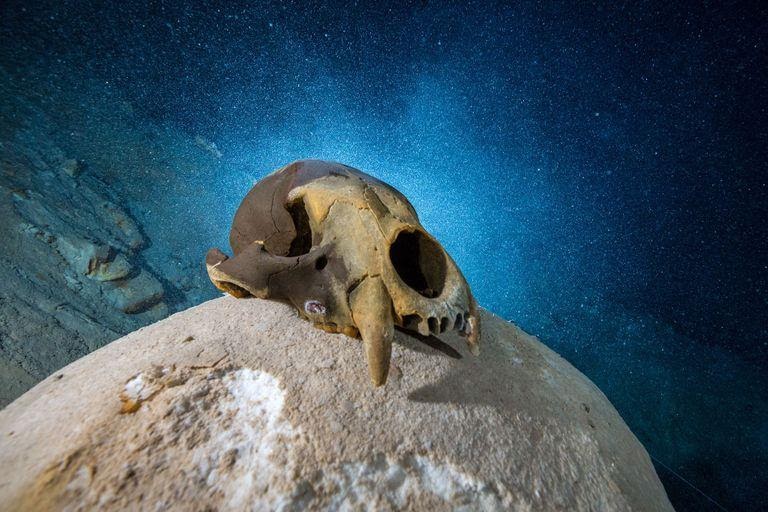
Figure 6 Hoyo Negro Expedition. © National Geographic Society.
Speleological explorations have achieved great advances, supported by technology and the transversality of science; traditional data recording methods, such as C14, because the collagen of the bones have degraded by the effect of water. So, a technique to measure the age of the bones have been developed; by measuring the age of the stalagmites that have been formed directly on the bones that lay in the caves. It has been concluded that the remains correspond to the transition of the Pleistocene and the Holocene. The shape of the skulls has been analyzed and it is considered that belong to human groups coming from the North, still not assimilated by the South or Central American populations. The preservation of over 80% of the skeletons is an indication that they laid on the spot they died; and that the remains were not drifted by water currents, so they must have been dry caves later inundated by the effects of sea level rise in the Yucatan peninsula. Besides, stalactites and stalagmites only grow on dry caves. Water flows interrupt the development of speleothems, which are formed drop by drop of calcite, and its growth can be measured as the rings in the trunk of a tree. Each one is a treasure we ought to preserve for the sake of science, and comprehension of our planet and our own evolution.
When we visit these wonderful places, we must be aware of the privilege it is, to share this scenery with the first dwellers of this part of America, and we must contribute to the preservation of their resting places; and of the entire hydrogeological system meandering the underground, barely mapped, and visited by modern humans. Let us become conscious travelers, truly connected with the places we visit; let us become the bridge for the future generations to enjoy these windows to the past intact.
Whenever you visit a cenote, a dry cave, or an underground river, do not venture into an unexplored cave, they are a health hazard for many reasons: venomous snakes, bat dung, mold, spores, and the feasibility of getting lost never to be found, or if you are lucky found after several days, deranged and probably nude, thus becoming a tabloid headline. Always choose the tourist provider that can demonstrate that their location has not been artificially enhanced or re-shaped; that abides to the local regulation and that their work towards the conservation of the system is notable, focusing on each visitor and measurable by international standards.
The underground river systems are prone to pollution by any kind of substance; contaminated waters by agrochemicals, sewage, oil, grease, or soap are a huge threat. Remember that our skin affects greatly the formations inside the caves; it is fundamental that we rinse our bodies before entering these geological treasures, eliminating any residue of cream, lotion, perfume, insect repellent or sunscreen; also removing from our bodies band aids or anything that can fall and be lost forever, such as jewelry, the most common lost item is engagement rings.
These treasures deserve to be preserved. We must do our part to ensure it happens.
For further reading and reference:
González, A.H. et Al (2014) The first human settlers on the Yucatan Peninsula: Evidence from drowned caves in the State of Quintana Roo (South Mexico). Article · January 2014. Recuperado de: https://www.researchgate.net/publication/290914765
Hering, F. et al (2014) Late Pleistocene to Early Holocene Sea-level and Climate Reconstruction and Indirect Dating of Bones Using Stalagmites from Underwater Caves in Quintana Roo, Mexico – An Outlook. Conference: Geo Frankfurt 2014 – Earth System Dynamics, Frankfurt, Germany. DOI: 10.13140/2.1.4445.0569
Johnson, W. Hilton (2018, July 30). Pleistocene Epoch. Encyclopedia Britannica. Disponible en: https://www.britannica.com/science/Pleistocene-Epoch
Kambesis P; Coke, J.G., IV (2016) The Sac Actun System, Quintana Roo, Mexico. Boletín Geológico y Minero, 127 (1): 177-192. ISSN: 0366-0176. Recuperado de : https://www.researchgate.net/publication/303139865_The_sac_actun_system_Quintana_Roo_Mexico/figures?lo=1
Monroy Ríos, E. (s/f) Sistema Sac Aktun – Longest Underwater Cave. Northwestern University Https://sites.northwestern.edu/monroyrios/sistema-sac-actun-en/
Cover photo: Sistema Sac Actun – Herbert Mayrl – Gran Acuífero Maya